 Proposal
to Drill a Transect in the Gulf of Cadiz, Proposal
to Drill a Transect in the Gulf of Cadiz,Proposal to Drill a Transect in the Gulf of Cadiz, Easter Central North Atlantic and Adquire and Accompanying Suite of Multi-Channel Seismic Data Up to 8-10 Seconds Two-Way Travel Time Penetration Objetives: To drill through a marine section including extensive slump and thrust blocks, and debris flows, undelying salt layers, and penetrate basement, identifying it. Background: DSDP Site 135 has identified a pelagic and turbidite section. In recent multi-channel seismic data farther inland, large slump blocks and associated down-dip thrusts incorporating allochthonous salt adjacent to the Iberian continental rise until reaching DSDP 135. This gravity-driven complex apparently extends over 400 km. Continental-based geologic interpretations
suggest that the western limit of the Gibraltar Arc may extend as far west
as the Horseshoe Abyssal plain.Tectonics associated with the Azores Gibraltar
lines suggest diferent origin.
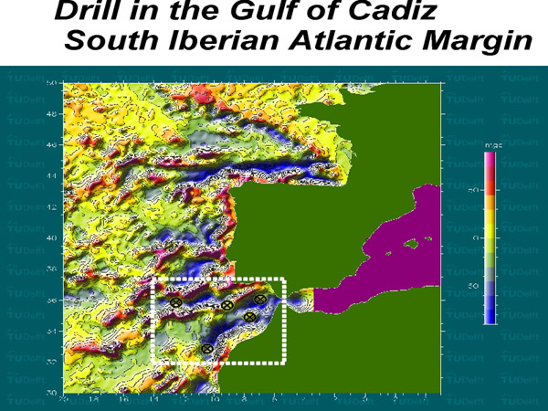
Scientific objetives: There are two-fold scientific objetives Collect sediment and basement data to improve seismic sampling and collection of geoacustic processing. The shallowest, most up-dip, well would be designed to drill through an outer continental rise sequence, penetrate up-thrust blocks with possible allochthonous salt and ultimate reach basement of either continental or oceanic origin (Suggested drill hole location 36º N, 7º W) A second well could be designed to sample sediment cover, thrust plain, and possible allochthonous salt and determine wheter thrust has incorporated sediment cover into deformation zone (Suggested drill hole 36ºN, 9-10ºW) Third and deepest well is to sample abyssal palin sediment with extensive debris flow material to underlying thrust blocks. Collection of velocity, density, and acoustic attenuation data to be incorporated into final processing of associated multichannel seismic data (Suggested drill hole location 36ºN, 10-11ºW) 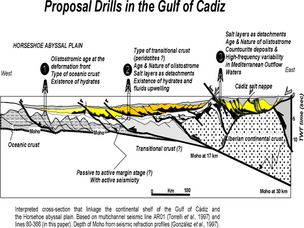
|