The
term "Olistostrome": Mediterranean mega allochthons towards the oceanic
crust
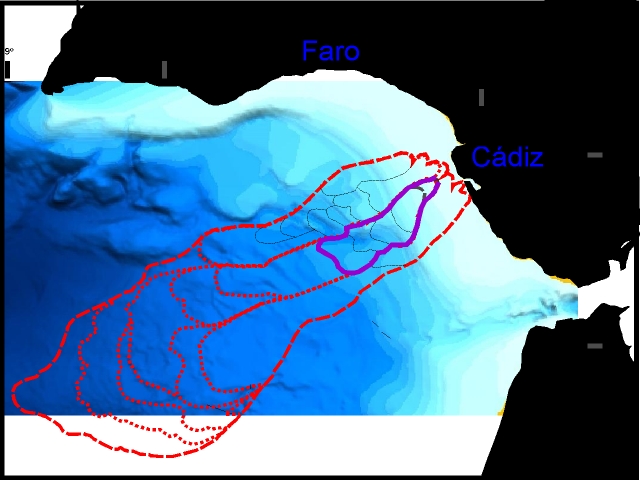
Advancing salt sheets along the frontal imbricate thrusting of the Betic-Rifian accretionary wedge (Iberian-Moroccan Atlantic continental margin) trigger down-slope movement of giant allochthonous masses (Fig.1) . These are detached from the front of accretionary wedge by extensional low-angle normal faults (Fig. 2). These faults initiate salt tectonics, including diapirism and withdrawal, and large mass-wasting from the shelf and upper slope as far west as to the Eastern Horseshoe and Seine abyssal plains.

From:
Somoza, L., A. Lowrie & Maestro, A. 1999. Allochtonous Blocks as Hydrocarbon Traps in the Gulf of Cadiz. Offshore Technology Conference (OTC), Deepwater Exploration and Development II, 10889: 571-577.
Salt-floored gravity-driven ramps along low-angle detachments link extensional structures (roll-over anticlines, listric growth faults and counter-regional growth faults) in the shelf to downdip folding , thrusting and salt sheets along the outer slope and upper slope of the Gulf of Cadiz. Salt-withdrawal growth fault basins developed on the shelf reflect two stages of high subsidence rates from the Late Tortonian to Late Messinian (200 to 400 m/Ma) and from Early Pliocene to Late Pliocene (100 to 150 m/Ma). These migrating allochthons apparently may have travelled up to 400 km down slope , originating along the Iberian and Moroccan continental margins. "The Cadiz Salt Nappe"
From:
Somoza, L., A. Lowrie & Maestro, A. 1999. Allochtonous Blocks as Hydrocarbon Traps in the Gulf of Cadiz. Offshore Technology Conference (OTC), Deepwater Exploration and Development II, 10889: 571-577.
Methane hidrates , slopes and slumps It is believed that hydrates might significantly inhibit the process of consolidation and mineral cementation.
Geologic hazard and slope stability (From Ingo Pecher WHOI HomePage)
Continued sedimentation may lead to a burial of hydrated sediments beneath the HSZ. Hydrates, which might have acted as metastable bonding agents within the HSZ, dissociate leaving layers of underconsolidated sediments at the BHSZ. Additionally, excess pore pressure may build up at this depth due to continued formation of free gas in conjunction with a low permeability of the hydrated sediments above. An upward movement of the BHSZ e.g. resulting from an increase of bottom water temperature might accelerate this process. Thus, the BHSZ acts as a potential zone of weakness, which might lead to huge slumps triggered e.g. by gravitational loading or seismicity (Kvenvolden, 1994).
There is strong evidence of slope failure being associated with hydrates offshore the southeastern U.S. coast. displays the distribution of slumps in this area together with hydrate distribution. Locations of slides obviously concentrate slightly seaward of the line at which the hydrate stability zone intercepts the seafloor, though the gentle dip of the seafloor of at these depths would indicate a relatively stable slope (Booth et al., 1994).
Other possible geologic risk factors which might be linked with hydrates are submarine mud volcanos such as in the Caspian Sea (Ginsburg et al., 1992) and the Black Sea (Lebedev, 1994). The effect of hydrates on sediment stability is also of interest for offshore engineering (e.g. Brooks et al., 1994).
References:
KVENVOLDEN, K. A. Natural gas hydrate occurrence and issues. In International conference on natural gas hydrates (New York, 1994), E. D. Sloan, J. Happle, and M. A. Hnatow, Eds., vol. 715, Plenum Press, pp. 233-246.
LEBEDEV, L. Tectonic features of the shale diapirs and mud volcano distribution in sediments of the Caspian, Black and Azov seas. In Gas in marine sediments (Nioz, Texel, Netherlands, September 1994), The shallow gas group. abstract.
¿Mega submarine slumps, earthquakes and tsunamis? A tsunami is a series of very long wavelength ocean waves caused by the sudden displacement of water by earthquakes, landslides, or submarine slumps. Ordinarily, tsunamis are produced only by earthquakes exceeding magnitude 7.5. In the open ocean, tsunami waves travel at speeds of 600-800 kilometers per hour, but their wave heights are usually only a few centimeters. As they approach shallow water near a coast, tsunami waves travel more slowly, but their wave heights may increase to many meters, and thus they can become very destructive.
From: Noson, Qamar, and Thorsen, Washington State Earthquake Hazards, 1988, Washington Division of Geology and Earth Resources Information Circular 85, p. 11, p.66.
The Mediterranean Outflow Water (MOW): Climate changes and oceanographic considerations
High-resolution stratigraphy of the shelf wedges
The stratal architecture of the Gulf of Cadiz continental margin (SW Spain) has been analyzed by using
single-channel, very high-resolution seismic reflection profiles. An evolutionary scheme of asymmetrical depositional sequences is proposed that was governed by the Late Pleistocene-Holocene sea-level fluctuations. Stratigraphic analysisdefined 14 seismic units, that are configured into two major type-1depositional sequences related to 4th-order eustatic sea level changes(100-110 ka). Within these sequences, minor asymmetrical depositional sequences have been recognized related to 5th-order eustatic cycles (22-23ka) superimposed and modulated by the regressive trends of 4th-ordercycles. In 5th-order depositional sequences, the forced regressive andlowstand deposits are Volumetrically dominant. They cause the main progradation of the margin in such a way that they form the margin structure almost entirely.From Somoza. L. et al. 1997. Continental-Shelf Architecture and Sea-Level Cycles - Late Quaternary High-Resolution Stratigraphy of the Gulf-of-Cadiz, Spain. Full source: GEO-MARINE LETTERS 1997, Vol 17, Iss 2, pp 133-139