
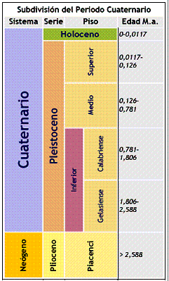
El Cuaternario y sus divisiones estratigráficas oficiales.
La información contenida aquí es una traducción de la existente en http://www.quaternary.stratigraphy.org.uk/
Las Series y Sistemas Estratigráficos se encuentran formalmente definidos por Secciones y/o Puntos Estratotipos Globales (GSSP), de entre los cuales dos han sido ratificados dentro de los últimos 2,7 millones de años. La Subcomisión de Estratigrafía del Cuaternario de la ICSU posee distintos grupos de trabajo dedicados a la definición de GSSPs para la subdivisión del Periodo Cuaternario (Pleistoceno y Holoceno). La consulta a todos los GSSPs propuestos y ratificados hasta la fecha puede consultarse en la página web de la IUGS ICS www.stratigraphy.org
Es importante tener en cuenta las diferencias entre los conceptos de Cronoestratigrafía y Climatoestratigrafía. El primero, se refiere la división del tiempo geológico tal y como se registra en las secuencias rocosas, mientras que el segundo, es la división del tiempo geológico basada en las oscilaciones climáticas ocurridas en el pasado. Ambos tienen su propia historia que puede consultarse desde los links que aparecen al final de esta página.
La Subcomisión de Estratigrafía del Cuaternario publicó en el año 2009 su propuesta para la definición formal del Periodo Cuaternario en el Journal of Quaternary Science (2009, Vol 25). Aquí adjuntamos el abstract del mencionado trabajo
Ratificación Formal del Periodo/Sistema Cuaternario y de las Series/Épocas Pleistocenas con base a 2.58 Ma
Gibbard, P. L., Head, M. J., Walker, M. J. C. and the Subcommission on Quaternary Stratigraphy.ABSTRACT - In June 2009, the Executive Committee of the International Union of Geological Sciences (IUGS) formally ratified a proposal by the International Commission on Stratigraphy to lower the base of the Quaternary System/Period to the Global Stratotype Section and Point (GSSP) of the Gelasian Stage/Age at Monte San Nicola, Sicily, Italy. The Gelasian until then had been the uppermost stage of the Pliocene Series/Epoch. The base of the Gelasian corresponds to Marine Isotope Stage 103, and has an astronomically tuned age of 2.58 Ma. A proposal that the base of the Pleistocene Series/Epoch be lowered to coincide with that of the Quaternary (the Gelasian GSSP) was also accepted by the IUGS Executive Committee. The GSSP at Vrica, Calabria, Italy, which had hitherto defined the basal boundary of both the Quaternary and the Pleistocene, remains available as the base of the Calabrian Stage/Age (now the second stage of the revised Pleistocene). In ratifying these proposals, the IUGS has acknowledged the distinctive qualities of the Quaternary by reaffirming it as a full system/period, correctly complied with the hierarchical requirements of the geological timescale by lowering the base of the Pleistocene to that of the Quaternary, and fully respected the historical and widespread current usage of both the terms Quaternary and Pleistocene.
La Definición del Periodo/Sistema Cuaternario y de las Series/Épocas Pleistocenas
Gibbard, Ph. & Head, M J. Quaternaire, 20, (2), 2009, 125-133ABSTRACT - The Quaternary is characterised by the development of widespread glaciations in temperate northern regions, and by associated physical and biotic readjustments. As a chronostratigraphical term it has attracted considerable debate. There has long been acceptance that the Quaternary should begin at the first indication of refrigeration in the Mediterranean region, which for spurious reasons was placed at 1.8 Ma. Following protracted discussions, led by the International Subcommission on Quaternary Stratigraphy (ISQS) and supported by the International Union for Quaternary Research (INQUA), the International Commission on Stratigraphy has now officially agreed that the Quaternary will henceforth begin at 2.6 Ma within a 2.8-2.4- Ma interval of profound change in EarthÕs climate system. The base of the Gelasian Stage (previously Pliocene) at 2.588 Ma offered an existing global stratotype section and point (GSSP) to define the base of the Quaternary. However, adopting this measure also necessitated lowering the base of the Pleistocene from its previously defined 1.8 Ma to that of the Quaternary to maintain hierarchical order. Acceptance of this proposal recognises the distinctive qualities of the Quaternary, complies with the hierarchical requirements of the geological time scale, and respects the historical and widespread current usage of both terms Quaternary and Pleistocene.
Definición del tránsito Pleistoceno Medio-Superior
P. L. Gibbard (2003). THE EEMIAN INTERGLACIAL: A GLOBAL PERSPECTIVE. Global and Planetary Change, Volume 36, Issue 3 , 201-208
ABSTRACT - The definition of a Middle–Upper Pleistocene Subseries boundary is discussed. This boundary is at present not formally defined, but has up till now been placed at the beginning of the Last Interglacial (Eemian, Mikulino, Sangamonian, etc.) or Marine Isotope Stage 5. Although it may seem attractive to define the boundary in an ocean sediment sequence, the inherent imprecision of most of such sequences, resulting from slow sedimentation rate, combined with the effects of bioturbation, suggests that for high-resolution stratigraphical purposes they are generally unsuitable for the definition of `golden spike'-type, `time–plane' boundaries. It is therefore proposed that the Saalian–Eemian stage boundary, and thus the Middle–Upper Pleistocene Subseries boundary-stratotype be defined from a terrestrial locality at -63.5 m below surface in the Amsterdam-Terminal borehole, The Netherlands. This parastratotype locality is also to be proposed as the Eemian Stage unit-stratotype.
Definición y datación del GSSP (Global Stratotype Section and Point) para la base del Holoceno utilizando el Sondeo de Hielo Greenland NGRIP ice core, y registros auxiliares específicos.
Mike Walker, et al. (2009).Journal of Quaternary Science, Vol 24, 3-17.
ABSTRACT - The Greenland ice core from NorthGRIP (NGRIP) contains a proxy climate record across the Pleistocene-Holocene boundary of unprecedented clarity and resolution. Analysis of an array of physical and chemical parameters within the ice enables the base of the Holocene, as reflected in the first signs of climatic warming at the end of the Younger Dryas/Greenland Stadial 1 cold phase, to be located with a high degree of precision. This climatic event is most clearly reflected in an abrupt shift in deuterium excess values, accompanied by more gradual changes in 18O, dust concentration, a range of chemical species, and annual layer thickness. A timescale based on multi-parameter annual layer counting provides an age of 11 700 calendar yr b2 k (before AD 2000) for the base of the Holocene, with a maximum counting error of 99 yr. A proposal that an archived core from this unique sequence should constitute the Global Stratotype Section and Point (GSSP) for the base of the Holocene Series/Epoch (Quaternary System/Period) has been ratified by the International Union of Geological Sciences. Five auxiliary stratotypes for the Pleistocene-Holocene boundary have also been recognised.
© Walker et al. 2009, Journal of Quaternary Science, 24, p. 3-17, John Wiley & Sons, Ltd. Digital Object Identifier (DOI) 10.1002/jqs.1227
El Antropoceno
El término Antropoceno es utilizado informalmente para describir el periodo geológico más reciente de la historia de la Tierra a partir del cual la actividad humana ha tenido un impacto global en los ecosistemas terrestres. Todavía no posee un inicio reconocido oficialmente, pero se le hace coincidir con la Revolución Industrial acaecida a partir de finales del Siglo XVIII. Otros científicos ligan su inicio con eventos más antiguos como es el comienzo de la agricultura (Periodo Neolítico). El término fue acuñado en el año 2000 por el Premio Nobel de Química Atmosférica Paul Cruzten, el cual indicó que la intervención humana sobre el planeta durante los últimos siglos era lo suficientemente significativa como para introducir un nuevo Periodo Geológico. Este nuevo concepto está ganando adeptos con la publicación de diferentes artículos desde el año 2005.
Are we now living in the Anthropocene?
Jan Zalasiewicz et al., (2008).GSA Today. v. 18, no. 2, doi: 10.1130/GSAT01802A.1.
ABSTRACT - The term Anthropocene, proposed and increasingly employed to denote the current interval of anthropogenic global environmental change, may be discussed on stratigraphic grounds. A case can be made for its consideration as a formal epoch in that, since the start of the Industrial Revolution, Earth has endured changes sufficient to leave a global stratigraphic signature distinct from that of the Holocene or of previous Pleistocene interglacial phases, encompassing novel biotic, sedimentary, and geochemical change. These changes, although likely only in their initial phases, are sufficiently distinct and robustly established for suggestions of a Holocene–Anthropocene boundary in the recent historical past to be geologically reasonable. The boundary may be defined either via Global Stratigraphic Section and Point (“golden spike”) locations or by adopting a numerical date. Formal adoption of this term in the near future will largely depend on its utility, particularly to earth scientists working on late Holocene successions. This datum, from the perspective of the far future, will most probably approximate a distinctive stratigraphic boundary.
Otros artículos de interés.
- Ellis, Erle (Lead Author); Jay Gulledge (Topic Editor). 2008. "Anthropocene." In: Encyclopedia of Earth. Eds. Cutler J. Cleveland (Washington, D.C.: Environmental Information Coalition, National Council for Science and the Environment).
- Artículo - Jan Zalasiewicz, Mark Williams, Will Steffen & Paul Crutzen (2010). The New World of the Anthropocene. Environ. Sci. Technol., 44, 2228–2231.
- New Earth Epoch Has Begun, Scientists Say - National Geographic.com. Artículo divulgativo publicado el 6 de abril de 2010.
Estratigrafía del Cuaternario
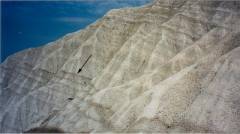
Base del piso Gelasiense (Gelasian) en el Monte San Nicola, Sicilia (Italia). Estratotipo de la Base del Cuaternario ratificado por la International Union of Geological Sciences (IUGS) a propuesta de la Subcomisión de Estratigrafía del Cuaternario.
http://www.quaternary.stratigraphy.org.uk/
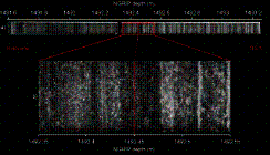
Estratigrafía visual del sondeo de hielo North GRIP entre 1491,6 y 1,493 metros de profundidad donde se ha definido el GSSP para la base del Holoceno (Walker et al., 2008, Journal of Quaternary Science) Published online in Wiley InterScience DOI: 10.1002/jqs.1227
http://www.interscience.wiley.com
En Europa y Norte América el Holoceno se subdivide en las etapas Preboreal, Boreal, Atlántico y Subatlántico, que corresponden a los periodos climáticos de la Escala de Blytt-Sernander. En la Actualidad, y a nivel práctico, es muy común utilizar la estratigrafía de los estadios isotópicos marinos al referirnos a las diferentes subdivisiones del Cuaternario.
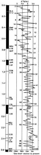
2,6 Millones de años de Cambios climáticos. En la Curva, los números impares representan periodos cálidos (interglaciares o interestadiales) y los números pares se refieren a los periodos fríos (glaciares o estadiales). La definición de la curva de variaciones climáticas se establece en base a las variaciones de las relaciones isotópicas O18/O16. (δ O18.) extraídas de la composición química de los caparazones calcáreos de microfauna marina (foraminíferos) en sondeos oceánicos profundos de registro continuo.